Guide for Truck Parking Information Management Systems (2025)
Chapter: 4 Designing TPIMS

CHAPTER 4
Designing TPIMS
This chapter focuses on the design tasks for transportation agencies to carry out to implement the TPIMS program that was envisioned in the project planning stage. The design of the system must meet the system requirements developed in the systems engineering development process. This chapter discusses the required design steps and documentation development required to obtain a contractor (if needed) to build the supporting infrastructure and implement system software in the back office.
To implement a TPIMS deployment, an agency can take the following steps (discussed in the subsections of Chapter 4):
- Identify a Detection Technology.
- Determine Methods for Site Surveillance.
- Design Site Infrastructure.
- Select Roadside Assets.
- Determine Data Processing Tools.
- Evaluate Supporting Network Infrastructure.
- Consider Methods for Information Sharing.
- Choose Data Exchange Protocols.
Identify a Detection Technology
Based on the count methodology (discussed in Chapter 3) that is ultimately selected, the physical layout of the truck parking facility, and the requirements established as part of the system requirements document, one of the first design steps is to identify a detection technology that provides accurate monitoring. Several detection technologies may provide the required functionality, which allows for a comparative assessment of the advantages and disadvantages of each option. The results of the assessment could help identify the technology and system that best meets the functional requirements. Often, a pilot test can be used to confirm whether the proposed product or competing products will function as needed before deploying them at all sites.
The installation requirements of the system must be established as well, in accordance with the selected technologies. If the technologies need supporting infrastructure, such as a pole or gantry, structure placement must be determined, and the structure must be incorporated into the design plans.
Available Detection Technologies
Table 6 summarizes five technologies available for truck parking availability data collection and provides information on variants and combinations of the technologies. Legacy methods,
Table 6. Summary of truck parking availability data collection technologies.
| Technology | Summary |
|---|---|
| Magnetometer |
|
| Video Detection |
|
| Microwave Radar |
|
| Laser |
|
| Mobile Application (Digital Occupancy and Crowdsourcing Methods) |
|
such as inductive loops or access gates, as well as variants of magnetometers, are not listed in the table but are described in the text that follows.
Many types of monitoring technologies are available (MAASTO 2016, North Carolina Department of Transportation 2017, Tucker and Frost 2018, Illinois Department of Transportation 2019, I-10 Corridor Coalition 2020), and the following technologies listed are among those that are frequently utilized to gather real-time parking availability, as discussed in various literature reviews conducted by agencies that embarked on a TPIMS effort. It is important to note that this list is not exhaustive, given the ever-evolving applications of technology to monitor truck parking.
Technologies are listed by their applicability to either the entrance and exit count method or the space occupancy count method. The digital occupancy and crowdsourcing count methods typically do not require the installation of physical infrastructure, and there are no technologies listed for them here.
Entrance and Exit Counting Technologies
Magnetometer
In-pavement magnetometer sensors, such as the one shown in Figure 12, are used by multiple state DOTs (MAASTO 2016), and are easily installed. They detect changes in the surrounding magnetic field caused by ferrous metal objects. When a vehicle passes over a magnetometer, it senses the change and counts the vehicle as it enters or exits the lot. The magnetometer is calibrated to determine when the vehicle has passed and resets the reference magnetic field to wait for a change, indicating that a new vehicle has passed over the sensor. Most magnetometer sensors are wireless and require minimal effort to install. Magnetometer sensors are a proven technology and are reliable and inexpensive compared to some other counting technologies. Battery life for these sensors has been the most significant challenge identified.
Wireless versions of these sensors require a wireless access point or “node” to communicate information to the remainder of the TPIMS. These sensors also require replacement if the roadway is resurfaced. Installation parameters should be confirmed when used on rigid pavement Portland cement concrete surfaces, as the presence of reinforcing steel may impact performance.
Video Detection
Video detection technology can be used to count and classify vehicles entering and exiting parking areas. Video cameras on their own do not provide accurate counts, but with strong video analytical algorithms, video technology can be a reliable vehicle counting method (I-10 Corridor Coalition 2020). However, video has a limited field of view and is sometimes limited by the geometry of the entrance or exit to a parking area. To classify vehicles, video cameras tend to need a full view of the vehicle to determine if it is a truck that should be counted toward a parking space versus a car that may not be counted. Also, weather and lighting conditions may hamper a camera’s ability to detect vehicles and provide an accurate vehicle count. Figure 13 shows a screen capture of a video monitoring system interface. Most commercial off-the-shelf products made for traffic detection employ a predefined zone-based or trip-line detection method, but advances in video analytics are rapidly being enhanced to use object recognition and tracking to count and classify vehicles in non-ideal conditions, such as slow or stopped speeds, bidirectional traffic, and undefined lanes more accurately.
Microwave Radar
Microwave radar sensors are mounted on poles and typically count vehicles from a side-fired or above the driveway configuration. Fixed radar sensors are popular for arterial mid-block
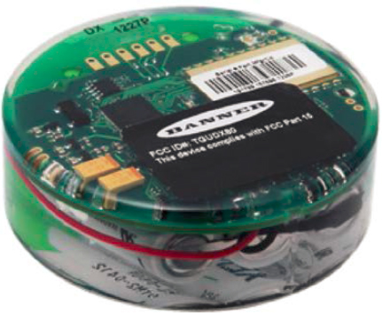
Figure 12. Example of a magnetometer sensor.
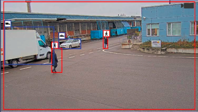
Figure 13. Video detection screenshot.
and freeway management, sending out two radar beams at a fixed distance apart to count and determine the speed of each vehicle. It then takes the time measured between the front of the vehicle and the back of the vehicle passing to calculate its length for classification. Figure 14 provides a diagram of a typical fixed radar system setup.
Since vehicles entering and exiting parking lots are often accelerating, decelerating, or otherwise moving at inconsistent speeds, the calculations may not always result in a correct identification
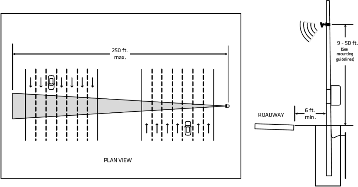
Figure 14. Radar setup diagram.
or an accurate count. Additionally, oddly shaped trailers and barrier walls can reduce the effectiveness of detectors at driveways. These limitations have been experienced during testing for truck parking projects in Florida, Wisconsin, and Michigan. Background objects, such as parking area maintenance vehicles, may also result in inaccurate counts. This was seen in Wisconsin when a side-mounted radar registered a zero-turn lawnmower as a truck (MAASTO 2016).
Laser
Laser technology is a recent addition to the tools available for truck parking detection. Laser sensors are based on LIDAR technology. At the entrance and exit points, a laser placed overhead or along the side of a lane can record an image of a vehicle, which is then used to count and classify. An image of one laser system is shown in Figure 15. The depth and width of the laser array can be adjusted for each individual parking area to maximize coverage of entrances and exits. Lasers and their accompanying software packages are the most expensive of the entrance and exit technologies to date. Lasers can work under most weather and lighting conditions to provide the most accurate counts and vehicle classifications of the methods surveyed and were used in an FMCSA project in Tennessee (Perry et al. 2015).
Loop Detectors
Loop detectors are among the basic traffic detection technologies, often used for traffic counting and traffic signal actuation. They consist of a wire that is embedded in the ground, typically in the pavement. Vehicles passing over or stopping within the detection area of an inductive-loop detector decrease the inductance of the loop. The electronics unit in a nearby cabinet senses this event as a decrease in frequency and sends a pulse to the controller, signifying the passage or presence of a vehicle. Single-loop detectors are very effective at counting vehicles but cannot accurately determine speed or classification on their own. For speed/classification needs, two loop detectors are needed along a travel lane.
While loop detectors are often used to help actuate an access gate at a parking area, they are not often used for TPIMS purposes. A logical choice would be to use them at entrances and exits to collect counts, as they currently provide that service in the context of traffic monitoring. The literature identified some examples of loops being used in Germany for monitoring parking
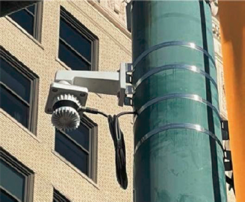
Figure 15. LIDAR module.
spaces (Perry et al. 2015), which is more closely tied to technologies discussed in the following subsection, but other instances are fairly limited.
Access Gate
Gate technology is likely the oldest form of entrance/exit detection. It is a very basic technology in which the gate restricts the passage of vehicles, and an onboard count unit quantifies how many vehicles have entered or exited a lot based on how it is triggered. Some gate systems use the detection methods cited above to trigger the gate, whereas others require a keycard, code, or payment to access the parking facility.
Gate technologies have been used in other parking management systems for decades. Since they naturally restrict entry, gate technologies can collect fairly good estimates of parking availability for a facility. However, most systems have some form of reset capability, such as resetting the availability during overnight hours when the parking facility is not in use to resolve any errors.
Public-sector TPIMS generally does not involve access gates, as most of the facilities are public rest areas that allow for unrestricted access by the public. These instances tend to appear at private-sector lots, more often those with a reservation system and/or need for security.
Space Occupancy Detection Technologies
Magnetometer
In addition to their use case for entrance and exit count methods, magnetometers as detection sensors in specific parking spaces are also an option for space occupancy count methods. These sensors are easily installed in the pavement surface and are typically low maintenance. Wireless magnetometer sensors provide long battery life and can be mounted flush with the surface of the parking lot, making them resistant to snowplow damage. However, if a truck that is adjacent to another parking spot parks too close to the sensor, the magnetometer in that other space may detect a change in the magnetic field and incorrectly report that two parking spaces are occupied. The magnetometers must be calibrated to minimize the detection of trucks in adjacent parking spaces.
Some magnetometers are not suited for truck parking applications. If a truck is parked above some magnetometers for an extended time, the sensor may determine the ferrous material from the truck to be the new background magnetic field and, therefore, reset the space as unoccupied. Multiple sensors per truck space are often required to detect vehicles of varying lengths, such as tractors without trailers or recreational vehicles (RV) that may not be as long as a full tractor/trailer. The quality of the magnetometer installation can impact the longevity of these sensors.
These sensors require a wireless access point or “node” to communicate information to the remainder of the TPIMS. These sensors also require replacement if the roadway is resurfaced. Installation parameters should be confirmed when used on rigid pavement Portland cement concrete surfaces, as the presence of reinforcing steel may impact performance.
Combined Magnetometer and Microwave Radar
Microwave/magnetometer in-pavement sensors, shown in Figure 16, use radar to detect the presence of an object to determine if the space is occupied, while the magnetometer detects the presence of ferrous material to identify when a vehicle moves near the sensor. These sensors can ignore vehicles parked in adjacent spots while only counting the vehicle in the space it is placed in by combining the reflection of radar with the detection change in the magnetic field. This sensor is installed flush to the surface of the parking area and is easily maintained. These sensors do not present an issue for snow plowing. However, standing water and snow can make the detection of vehicles with the radar difficult. Multiple sensors per truck space are often required to detect vehicles of varying lengths, such as tractors without trailers or RVs that may not be as long as a full tractor/trailer.
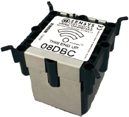
Figure 16. Example of a microwave/magnetometer unit.
These sensors require a wireless access point or “node” to communicate information to the remainder of the TPIMS. These sensors also require replacement if the roadway is resurfaced. Installation parameters should be confirmed when used on rigid pavement Portland cement concrete surfaces, as the presence of reinforcing steel may impact performance.
Magnetometer with Infrared
In-pavement infrared (IR)/magnetometer sensors are easily installed and use IR sensors to detect the vehicle as it occupies a space, similar to microwave/magnetometer sensors. IR sensors overall are reliable, low maintenance (once calibrated), and inexpensive compared to some other technologies. Most of these sensors are wireless and take very little effort to install. However, the IR sensors are susceptible to data quality degradation due to rainfall and snowfall if the sensors become covered; the IR sensors are also prone to being hit by snowplows that are clearing lots because they cannot be mounted sufficiently flush to the pavement surface. Figure 17 shows an example of an IR/magnetometer sensor.
These sensors require a wireless access point or “node” to communicate information to the remainder of the TPIMS. These sensors also require replacement if the roadway is resurfaced. Installation parameters should be confirmed when used on rigid pavement Portland cement concrete surfaces, as the presence of reinforcing steel may impact performance.
Video Detection
Another option for space occupancy detection is the use of pole-mounted video cameras viewing a dedicated number of spaces or an area available for parking. These cameras use video pattern recognition algorithms to determine if the spaces are occupied or unoccupied. Since each camera can only view a certain number of spaces, larger lots require more cameras, increasing the cost. Additionally, weather may have an adverse effect on the camera’s visibility and could affect reliability. The University of Minnesota developed a video detection system for truck parking, which is currently in use in Kansas at 18 public rest areas (Morris et al. 2017). Figure 18 shows a graphical representation of the algorithm steps used in the Minnesota system to determine space occupancy. The deployed system is highly accurate, but each facility requires detailed setup and
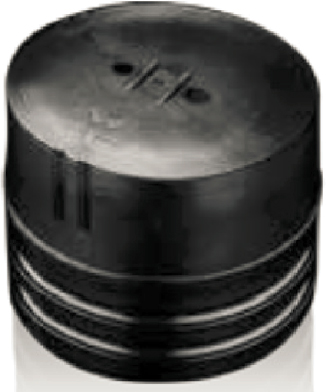
Figure 17. Example of IR/magnetometer sensor.
calibration. Calibration at each site requires observations in all weather conditions to achieve the highest levels of accuracy, which may take considerable time.
As previously discussed, any maintenance to the pavement in the lot may require the system to be recalibrated due to the changes in reflections and absorption of light. The use of video analytics for truck parking monitoring is a growing market with vendors developing new products.
Radar Detection
Radar detection systems have been developed to monitor truck parking space occupancy in recent years. This technology uses microwave radar to monitor the location of parked trucks.
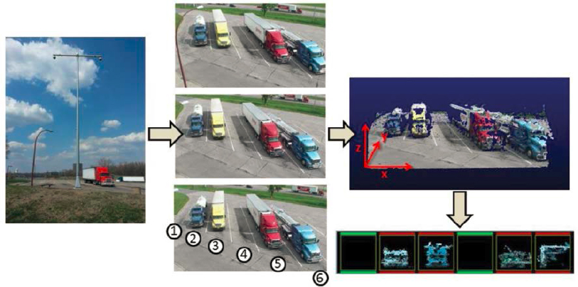
Figure 18. University of Minnesota video detection algorithms.
Similar to video detection technology, a radar unit can only monitor a limited number of parking spaces, so multiple radar units are required to monitor a whole truck parking area. Radar sensors can operate in the presence of the most adverse environmental factors, such as smoke, rain, sleet, heavy snow, and low light.
Selection Considerations
When selecting a detection technology there are several design considerations that will influence the selection.
- Traffic on Driveways. Does the parking area have driveways that are exclusively used by truck traffic? This is typically the case when the truck parking area is separated from the passenger vehicle parking. If the entrance and exit driveways are used by mixed traffic, the detection technology must be able to classify vehicles so the number of trucks can be counted.
- Driveway Geometrics. The width and length of driveways impact how effectively vehicles can be counted and classified. A longer and narrower driveway is easier to monitor because the paths that trucks follow will be more consistent.
- Intrusive Versus Non-Intrusive. Intrusive detection technology must be installed in the pavement, which has several impacts. First, the installation process will require the driveway or parking space where the detection technology is being installed to be closed to traffic; there is a similar impact when maintenance is required. A second impact will occur when the driveway or parking area pavement must be replaced. When pavement is replaced, the detection technology must be removed and reinstalled or replaced.
- Number of Sensors to Maintain. Any detection technology that is used will have failures that will require repair or replacement. The more sensors that are installed, the more maintenance will be required.
- Exposure to Trucks. Trucks are large and heavy vehicles, so they can have a significant impact on sensors. This includes loading on in-pavement sensors and trucks striking sensors mounted on poles.
Determine Methods for Site Surveillance
To ensure system accuracy, system operators must be able to independently determine the actual number of available spaces. This could be done with dedicated persons (such as an on-site parking lot owner, an agency’s maintenance division, or law enforcement) visiting the sites and doing manual counts. Since this requires resources and time to reach these sites, remote video surveillance is typically used. This ability is critically important when an entrance and exit counting methodology is being used. Based on the experience of existing systems using this methodology, accuracy checks and count resets will be required once or twice a day in most cases (MAASTO 2016). In most instances, on-site CCTV cameras provide real-time images of parking facilities to help confirm that the number of available truck parking spaces reported by the sensors is accurate. With this approach, one operator can manually count all parking sites remotely from their central operations center, such as a traffic management center. If the number of available spaces reported by the sensors is not accurate, these real-time video feeds can help inform the count.
As more systems are deployed and Artificial Intelligence/Machine Learning becomes more widespread, semiautomatic corrections and alerts can be applied to reduce the manual labor burden of this critical task to ensure accuracy. As an example, in Wisconsin, the system data processing system was set up to email alerts if the system was computing more availability than possible based on lot capacity and would not subtract any more vehicles from the lot count until intervention from an operator (Wisconsin Department of Transportation 2016).
Based on the spatial configuration of the truck parking area and access routes to the parking facility, cameras must be strategically placed to provide a view of all parking spaces, as well as potential ingress and egress locations. In some parking areas, multiple cameras may be required to provide the needed views. The camera locations should take into consideration the power service locations and required communications connection along with site constraints such as trees and buildings that will impact the views available. The closer the cameras are to the power service and communications connection the lower the cost is for deployment. The structure on which the camera is mounted—often a pole—must also be designed.
Design Site Infrastructure
Once decisions are made on the detection technology and site surveillance methods to implement, a site design must be completed to determine where and how the detection technology will be installed along with the power and communications infrastructure that must be installed to support the system. The selected sensor technology will dictate where it must be installed. When selecting the locations where sensors will be installed, an important consideration is where informal truck parking typically occurs. Informal parking occurs when trucks are parked in locations not designated for truck parking such as along entrance and exit ramps or along the edge of a parking area. Informally parked trucks may be positioned at a location that occludes the camera view or radar/LIDAR signal. Some type of physical barrier may be desirable to prevent trucks from parking in critical areas that will impact the system’s performance.
Depending on detection technology and camera mounting requirements, it must be determined if new structures are needed for mounting. Some transportation agencies may allow existing structures to be used for mounting, whereas others may not. If new structures are required, they must be designed, or standard structures can be used. Tree trimming may also be required to improve line-of-sight for cameras and wireless communications.
It must be determined if power can be obtained from an existing service or if new electrical infrastructure is needed at the site. If an existing service is to be used, it must be determined where new branch circuits can be added to serve the detection technology and surveillance equipment. The electrical distribution systems for the site must be designed, including wire and circuit breaker sizes. The electrical connections will require the design of the conduit and pull box system to route cables underground.
If using hardwire communications, a conduit and pull box system must be designed to carry the communications cables from the detection technology and camera(s) to a network connection hub. With wireless communications, individual device locations can each have their own backhaul connection, or the devices on the site can be consolidated into one backhaul connection. For wireless communications signal strength must be tested to confirm sufficient bandwidth is available to support the system. The appropriate type of antenna will need to be determined to provide the required signal strength. If cellular wireless communications are used, it will be much more cost-effective to transmit images rather than video.
Plans and specifications must be produced, following local guidelines and standards, to direct the contractor (or other installer) on how to install the infrastructure and technology being used.
Select Roadside Assets
In the planning phases, the means to distribute information must be determined. If it was decided to distribute information via a roadside method, then the selection of roadside assets is a design decision that will need to be made. Based on research done under various TPIMS
deployments, roadside message signs have consistently been rated as the preferred dissemination method by commercial operators (MAASTO 2016). They are designed to provide real-time messages on the number of available truck spaces at upcoming truck parking areas. These signs can either be a static panel with a matrix display (the matrix updates to show the current number of reported spaces) or a full DMS.
Design considerations for roadside message signs include how far upstream from a truck parking area the sign should be located, as well as how many downstream truck parking locations are shown on the sign. Some of these decisions are driven by sign standards, such as the Manual on Uniform Traffic Control Devices (MUTCD) standards (FHWA 2023). The 11th Edition of the MUTCD includes a new Section 2I.15 covering truck parking signage. Spacing guidance is 3 to 5 miles upstream and no more than 60 miles.
In previous TPIMS design efforts, it was agreed that the decision to park at an upcoming truck parking area was a complex decision, so the ideal distance upstream from the exit to the parking area was determined to be 5 to 10 miles (MAASTO 2016). The final location for the signs was usually dictated by the availability of power service. Solar power is an option, but the maintenance cost for a solar power system should be taken into consideration. The availability of other truck parking facilities that are not part of the system should also be considered when locating the sign. If there is an interchange with private truck stops that have truck parking, it is beneficial to locate the TPIMS sign upstream of the interchange so a truck driver can see that the TPIMS parking area is nearly full, so stopping at a truck stop would make sense.
The amount of information that can be presented to drivers on a roadside message sign is limited, so the number of types of parking facilities can impact the number of locations shown. If parking facilities are of the same type (e.g., rest areas), then parking availability at three sites can be provided. If there is a mixture of rest area and truck parking-only sites, just two sites, the upcoming site and the next one, can be presented on the sign.
The lateral offset of the truck parking signs must be designed based on the roadway cross-section, the type of structure, and the required offset from the roadway travel lane. Some types of crash protection, such as a guard rail, may also need to be designed. Lateral offset, need for protection, and protection design will be dictated by the Roadside Design Guide (AASHTO 2011) and transportation agency standards.
The distance from existing signs must also be considered in the sign location selection. The MUTCD also provides minimum spacing between signs to allow drivers to process the information from one sign before reaching the next sign. When determining the minimum spacing criteria for use in determining sign locations, agencies can follow the guidance provided by the MUTCD.
Determine Data Processing Tools
In the planning phases, a key decision is selecting a method for processing data, with different models available to a transportation agency. Regardless of the selected model, the software or service needs to meet the system requirements that process raw data from the sensors into reportable parking space availability. The software or service must manage the incoming data, process the data to determine the number of available spaces, and make the available parking space information sharable. The software or service must also have a user interface that will allow for system operators to correct available space counts when needed.
Depending on the model used, it must be determined who will develop or provide the software application and where the application will reside. Some options include an agency-owned central
Table 7. Summary of truck parking availability data processing technologies.
| Technology | Summary |
|---|---|
| Central/Integrated Software |
|
| Independent Software |
|
| Software-as-a-Service |
|
or edge server or a cloud-based platform. Some type of data storage system will also be needed to facilitate data management and historical analysis. Table 7 summarizes three technologies related to truck parking availability data processing technologies.
The data processing system is also where corrections to counts, accuracy checks, and advanced algorithms are applied to ensure accurate data is provided to the various dissemination methods. No matter where the data is processed, these are critical functions to consider when establishing requirements for the data processing tools.
Evaluate Supporting Network Infrastructure
Network communication channels are required to facilitate data and information exchange. Depending on the sensor technology, there may be a need for network communications between remote units and a centralized access point. With all sensors, there will be a need to design the communications link between the sensor in the field and the application used to calculate parking availability. There must also be network communication channels to transmit the calculated truck parking availability data to roadside message signs, traveler information applications, and the systems data exchange API. The surveillance cameras that are typically part of the system must be able to transmit video or images back to an operations center for use in monitoring system accuracy. Another important consideration is cybersecurity when defining the functionality of the communications network to reduce the risk of unauthorized access and data theft.
The communications network infrastructure will be unique to each transportation agency deploying a TPIMS. The first step is to inventory existing communications network assets along the corridor where the TPIMS is being deployed. If there is agency-owned fiber in the corridor, the cost to make a connection to the fiber for the parking areas and signs could be a wise investment given the increased reliability and lack of a monthly fee to receive the service. If transportation
agency fiber is not available, cellular communications will likely be the most cost-effective option. Typically, there are long distances between parking areas, so the installation of new fiber or deployment of a point-to-point wireless network will not be cost-effective. If cellular backhaul is used, individual parking sites and sign locations need to be tested to confirm that the needed bandwidth can be provided by the cellular network.
Consider Methods for Information Sharing
Truck parking availability information, as a best practice, should be shared through existing agency traveler information systems beyond roadside signing. If decisions made in the planning phases lean toward the use of web-based information-sharing platforms, then it is important for a transportation agency to evaluate what options are available as part of the design. Most transportation agencies have existing traveler information systems that present travel-related information to the public to help them make informed decisions. These systems often have a website and, in some cases, may have a smartphone application. The existing system will need to be enhanced to present the parking availability information to the public. Stakeholders should be involved in the development of the enhanced interface to make sure the truck parking availability information is presented in an understandable manner and can potentially be accessible hands-free.
Table 8 summarizes nine technologies related to truck parking availability data distribution technologies.
Choose Data Exchange Protocols
As part of the planning and design process, a transportation agency needs to determine if it is valuable to share information with outside parties, such as other transportation agencies, third-party application providers (such as private-sector truck information services groups), and other users. For a TPIMS corridor deployment through multiple states, sharing of truck parking availability data will be required if roadside signs provide data for upstream parking areas. For example, the I-10 Corridor Coalition TPIMS deployment signs in one state must display availability for parking areas in adjacent states (I-10 Corridor Coalition 2020). To exchange the availability data between states the same API is used that will be provided to private third-party application providers of transportation data. The API can also be used to exchange data between different systems within a state.
If it is decided that truck parking availability data must be shared, an API must be designed and implemented to provide access to the data. To make the API functional, a data exchange specification must be established to help provide standardization on what data requests can be made and what data can be provided.
While there currently is no national standard for truck parking availability data exchange, the state transportation agencies involved in the MAASTO TPIMS deployment developed a regional TPIMS data standard (MAASTO 2018). The states involved in the I-10 Corridor Coalition decided to use the same data exchange standard for their TPIMS deployment (I-10 Corridor Coalition 2021). The data exchange specification must be provided to entities wanting to access the data in order to develop applications for disseminating TPIMS information. Adopting a data exchange standard used by other transportation agencies will increase the likelihood that a third-party developer will provide an agency’s TPIMS data in their applications since additional programming will not be required using an available API.
Table 8. Summary of truck parking availability data distribution technologies.
| Technology | Summary |
|---|---|
| Roadside Signs |
|
| Web-Based Platforms |
|
| In-Cab Systems |
|
| GPS Navigation Systems |
|
| Highway Advisory Radio |
|
| Citizens Band Radio |
|
| Other Radio Systems |
|
| Call-in Phone Systems |
|
| Travel Information Kiosks |
|
Documents That Support Design for TPIMS
The type of documents resulting from the design process will depend on the procurement method used to deploy the TPIMS. If a conventional design-bid-build process is followed, detailed plans, specifications, and cost estimates must be developed to allow for a low-bid letting. If a design-build process is used all that is needed is a high-level design that would produce 30%-complete or conceptual plans. If an agency decides to hire a service provider to implement a TPIMS, the service provider will do the design for the project and the agency must provide detailed requirements for the service provider to meet. Requirements need to include both construction-related items, e.g., hardware, communications, technology components, and integration, as well as operational requirements, e.g., system uptime, security, and accuracy.


